Is it rain or snow? Follow this link
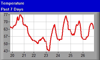
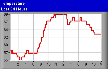
Temperature 77.0°F (Airport mtr004KEWN°F mtr003KEWN)
|
|
|
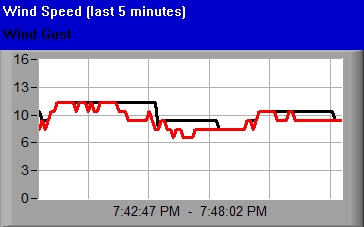
Wind Gust 9mph
|
|---|---|
|
Direction N
|
|
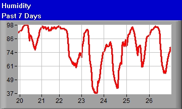
Humidity 48%
|


| Wind Chill 77.0
|
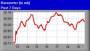
Barometer 30.02
|
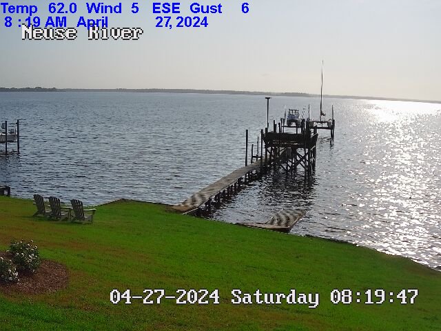
Viewing mouth of Upper Broad Creek, just below Northwest Creek and
Fairfield Harbour, taken South of Johnson Point facing ENE
Southern Craven-
Including the cities of New Bern, River Bend, Fairfield Harbor,
and Havelock
300 PM EDT Thu May 30 2024

.TONIGHT...Mostly clear this evening, then becoming partly
cloudy. Lows in the upper 50s. East winds 5 to 10 mph, becoming
southeast after midnight.
.FRIDAY...Mostly sunny. A slight chance of showers and
thunderstorms in the morning. Highs in the upper 70s. North winds
5 to 10 mph. Chance of rain 20 percent.
.FRIDAY NIGHT...Clear. Lows in the mid 50s. East winds 5 to
10 mph.
.SATURDAY...Sunny. Highs in the lower 80s. East winds 5 to
10 mph.
.SATURDAY NIGHT...Mostly clear in the evening, then becoming
partly cloudy. Lows in the lower 60s. South winds around 5 mph.
.SUNDAY...Mostly sunny. Highs in the mid 80s.
.SUNDAY NIGHT...Mostly cloudy. Lows in the upper 60s.
.MONDAY...Mostly sunny. Highs in the mid 80s.
.MONDAY NIGHT...Partly cloudy. Lows in the upper 60s.
.TUESDAY...Mostly sunny. Highs in the upper 80s.
.TUESDAY NIGHT...Partly cloudy. Lows in the upper 60s.
.WEDNESDAY...Mostly sunny. Highs in the mid 80s.
.WEDNESDAY NIGHT...Partly cloudy. Lows in the upper 60s.
.THURSDAY...Mostly sunny. Highs in the upper 80s.

$$
Pamlico Sound-
300 PM EDT Thu May 30 2024

.TONIGHT...NE winds 10 to 15 kt, becoming E 5 to 10 kt after
midnight. Waves around 2 ft this evening, then 1 ft. A slight
chance of showers and tstms late.
.FRI...NE winds 10 to 15 kt. Waves around 2 ft. A chance of
showers with a slight chance of tstms in the morning.
.FRI NIGHT...NE winds 10 to 15 kt, diminishing to 5 to 10 kt
after midnight. Waves around 2 ft in the evening, then 1 ft.
.SAT...N winds around 5 kt, becoming E in the afternoon. Waves
1 ft or less.
.SAT NIGHT...S winds around 10 kt. Waves 1 ft or less.
.SUN...SW winds around 10 kt, increasing to around 15 kt in the
afternoon. Waves 1 ft or less, then around 2 ft in the afternoon.
.SUN NIGHT...SW winds around 15 kt. Waves around 2 ft.
.MON...SW winds 10 to 15 kt. Waves around 2 ft in the morning,
then 1 ft.
.MON NIGHT...SW winds 10 to 15 kt. Waves around 2 ft in the
evening, then 1 ft.
.TUE...SW winds around 10 kt, becoming SE in the afternoon. Waves
1 ft or less.
.TUE NIGHT...S winds around 10 kt. Waves 1 ft or less.

Winds and waves higher in and near tstms.

$$
.Synopsis for Eastern North Carolina coastal waters...
Shortwave passing through tonight may bring a few showers.
Behind this wave, cooler and drier high pressure builds
overhead for the weekend. High pressure then builds offshore
early next week with temps returning to above normal.

$$
Neuse and Bay Rivers-
300 PM EDT Thu May 30 2024

.TONIGHT...NE winds 5 to 10 kt, becoming SE late this evening and
early morning, then becoming S late. Waves light chop,
diminishing to flat late.
.FRI...NE winds 5 to 10 kt, increasing to 10 to 15 kt in the
afternoon. Waves light chop, increasing to a moderate chop in the
afternoon. A slight chance of showers and tstms in the morning.
.FRI NIGHT...E winds 5 to 10 kt. Waves light chop.
.SAT...NE winds around 5 kt, becoming E in the afternoon. Waves
flat, increasing to light chop in the afternoon.
.SAT NIGHT...S winds 5 to 10 kt. Waves light chop.
.SUN...SW winds 5 to 10 kt, increasing to 10 to 15 kt in the
afternoon. Waves light chop, increasing to a moderate chop in the
afternoon.
.SUN NIGHT...SW winds 10 to 15 kt. Waves a moderate chop.
.MON...SW winds around 10 kt. Waves light chop.
.MON NIGHT...SW winds 5 to 10 kt. Waves light chop.
.TUE...SW winds 5 to 10 kt, becoming SE in the afternoon. Waves
light chop.
.TUE NIGHT...S winds 5 to 10 kt. Waves light chop.

Winds and waves higher in and near tstms.

$$
S of Cape Lookout to N of Surf City NC out 20 nm-
300 PM EDT Thu May 30 2024

.TONIGHT...E winds 5 to 10 kt, becoming S late. Seas 2 to 3 ft.
Wave Detail: E 2 ft at 4 seconds and SE 2 ft at 9 seconds.
Adjacent sounds and rivers light chop.
.FRI...N winds 5 to 10 kt, becoming NE 10 to 15 kt in the
afternoon. Seas 2 to 3 ft. Wave Detail: NE 2 ft at 5 seconds and
SE 2 ft at 8 seconds. Adjacent sounds and rivers light chop,
increasing to a moderate chop in the afternoon. A slight chance
of showers and tstms in the morning.
.FRI NIGHT...E winds 10 to 15 kt. Seas 2 to 3 ft. Wave Detail: E
2 ft at 4 seconds and SE 2 ft at 8 seconds. Adjacent sounds and
rivers a moderate chop.
.SAT...NE winds 5 to 10 kt, becoming E in the afternoon. Seas
around 2 ft. Wave Detail: E 2 ft at 5 seconds and SE 2 ft at
8 seconds. Adjacent sounds and rivers light chop.
.SAT NIGHT...S winds 5 to 10 kt. Seas around 2 ft. Wave Detail: E
2 ft at 7 seconds. Adjacent sounds and rivers light chop.
.SUN...SW winds 10 to 15 kt. Seas around 2 ft. Wave Detail: SW
2 ft at 4 seconds and E 2 ft at 7 seconds. Adjacent sounds and
rivers a moderate chop.
.SUN NIGHT...SW winds 10 to 15 kt. Seas 2 to 3 ft. Adjacent
sounds and rivers a moderate chop.
.MON...SW winds 10 to 15 kt. Seas 2 to 3 ft. Adjacent sounds and
rivers a moderate chop.
.MON NIGHT...SW winds 10 to 15 kt. Seas 2 to 3 ft. Adjacent
sounds and rivers a moderate chop.
.TUE...SW winds around 10 kt, becoming S in the afternoon. Seas
around 2 ft. Adjacent sounds and rivers light chop.
.TUE NIGHT...S winds around 10 kt. Seas around 2 ft. Adjacent
sounds and rivers light chop.

Winds and seas higher in and near tstms.

$$
Pine Knoll Shores, Salter Path, and Emerald Isle
1040 AM EDT Thu May 30 2024

.REST OF TODAY...
Rip Current Risk*...........Low.
Surf Height.................Around 1 foot.
Thunderstorm Potential**....None.
UV Index**..................Very High.
Weather.....................Sunny.
High Temperature............In the upper 70s.
Winds.......................North winds around 10 mph, becoming
                            east in the afternoon.
Tides...
   Atlantic Beach...........High 3.5 feet (MLLW) 01:30 PM EDT.

.FRIDAY...
Rip Current Risk*...........Low.
Surf Height.................Around 2 feet.
Thunderstorm Potential**....Low.
Weather.....................Mostly sunny. A slight chance of
                            showers and thunderstorms.
High Temperature............In the mid 70s.
Winds.......................Northwest winds around 5 mph, becoming
                            northeast in the afternoon.
Tides...
   Atlantic Beach...........Low 0.0 feet (MLLW) 08:30 AM EDT.
                            High 3.8 feet (MLLW) 02:31 PM EDT.

&&

Rip Current Risk Category
* Low Risk - The risk for rip currents is low, however,
life-threatening rip currents often occur in the vicinity of groins,
jetties, reefs, and piers.
* Moderate Risk - Life-threatening rip currents are possible in the
surf zone.
* High Risk - Life-threatening rip currents are likely in the surf
zone.

** For thunderstorm, waterspout, and UV definitions see:
https://www.weather.gov/beach/mhx

$$
Any
suggestions or requests please email
me by this link.
Last Updated 6:35pm on 5/30/24
Old Links


Updated at 6am
Today's Forecast for 2pm (updated at 6am)
Tomorrow at 2pm (updated at 6am)
2 Days From Now at 2pm (updated at 6am)
3 Days From Now at 2pm (updated at 6am)
4 Days From Now at 2pm (updated at 6am)
5 Days From Now at 2pm (updated at 6am)
6 Days From Now at 2pm (updated at 6am)
7 Days From Now

9 Days From Now
12 Days From Now
Updated at 6pm
2pm (updated at 6pm)
2 Days From Now at 2pm (updated at 6pm)
3 Days From Now at 2pm (updated at 6pm)
4 Days From Now at 2pm (updated at 6pm)
5 Days From Now at 2pm (updated at 6pm)
6 Days From Now at 2pm (updated at 6pm)
7 Days From Now
9 Days From Now
12 Days From Now
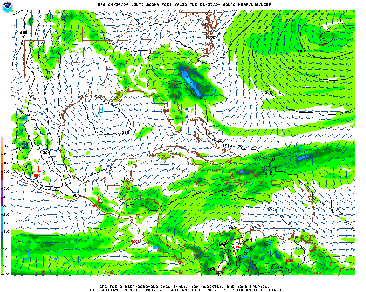
New Bern Area Weather Forecast
|
|
|
|
Weather Synopsis
.Synopsis for Eastern North Carolina coastal waters... Shortwave passing through tonight may bring a few showers. Behind this wave, cooler and drier high pressure builds overhead for the weekend. High pressure then builds offshore early next week with temps returning to above normal. $$ |
Neuse and Bay River Marine Forecast
Neuse and Bay Rivers- 300 PM EDT Thu May 30 2024 .TONIGHT...NE winds 5 to 10 kt, becoming SE late this evening and early morning, then becoming S late. Waves light chop, diminishing to flat late. .FRI...NE winds 5 to 10 kt, increasing to 10 to 15 kt in the afternoon. Waves light chop, increasing to a moderate chop in the afternoon. A slight chance of showers and tstms in the morning. .FRI NIGHT...E winds 5 to 10 kt. Waves light chop. .SAT...NE winds around 5 kt, becoming E in the afternoon. Waves flat, increasing to light chop in the afternoon. .SAT NIGHT...S winds 5 to 10 kt. Waves light chop. .SUN...SW winds 5 to 10 kt, increasing to 10 to 15 kt in the afternoon. Waves light chop, increasing to a moderate chop in the afternoon. .SUN NIGHT...SW winds 10 to 15 kt. Waves a moderate chop. .MON...SW winds around 10 kt. Waves light chop. .MON NIGHT...SW winds 5 to 10 kt. Waves light chop. .TUE...SW winds 5 to 10 kt, becoming SE in the afternoon. Waves light chop. .TUE NIGHT...S winds 5 to 10 kt. Waves light chop. Winds and waves higher in and near tstms. $$ |
Pamlico Sound Marine Forecast
Pamlico Sound- 300 PM EDT Thu May 30 2024 .TONIGHT...NE winds 10 to 15 kt, becoming E 5 to 10 kt after midnight. Waves around 2 ft this evening, then 1 ft. A slight chance of showers and tstms late. .FRI...NE winds 10 to 15 kt. Waves around 2 ft. A chance of showers with a slight chance of tstms in the morning. .FRI NIGHT...NE winds 10 to 15 kt, diminishing to 5 to 10 kt after midnight. Waves around 2 ft in the evening, then 1 ft. .SAT...N winds around 5 kt, becoming E in the afternoon. Waves 1 ft or less. .SAT NIGHT...S winds around 10 kt. Waves 1 ft or less. .SUN...SW winds around 10 kt, increasing to around 15 kt in the afternoon. Waves 1 ft or less, then around 2 ft in the afternoon. .SUN NIGHT...SW winds around 15 kt. Waves around 2 ft. .MON...SW winds 10 to 15 kt. Waves around 2 ft in the morning, then 1 ft. .MON NIGHT...SW winds 10 to 15 kt. Waves around 2 ft in the evening, then 1 ft. .TUE...SW winds around 10 kt, becoming SE in the afternoon. Waves 1 ft or less. .TUE NIGHT...S winds around 10 kt. Waves 1 ft or less. Winds and waves higher in and near tstms. $$ |
Atlantic Beach Forecast
Carteret- Including the cities of Morehead City, Beaufort, Newport, Atlantic Beach, and Emerald Isle 1248 AM EDT Fri Aug 17 2018 .REST OF TONIGHT...Partly cloudy. Lows in the upper 70s. Southwest winds 10 to 15 mph. .FRIDAY...Mostly sunny with a slight chance of showers and thunderstorms. Breezy with highs in the upper 80s. Southwest winds 15 to 20 mph. Chance of rain 20 percent. .FRIDAY NIGHT...Partly cloudy in the evening, then becoming mostly cloudy. A slight chance of showers and thunderstorms. Breezy with lows in the upper 70s. Southwest winds 15 to 20 mph. Chance of rain 20 percent. .SATURDAY...Partly sunny with a chance of showers and thunderstorms. Breezy with highs in the upper 80s. Southwest winds 15 to 20 mph with gusts up to 30 mph. Chance of rain 50 percent. .SATURDAY NIGHT...Showers and thunderstorms likely. Breezy with lows in the upper 70s. Southwest winds 15 to 20 mph. Chance of rain 70 percent. .SUNDAY...Showers and thunderstorms likely. Highs in the mid 80s. Chance of rain 70 percent. .SUNDAY NIGHT...Mostly cloudy. Showers and thunderstorms likely, mainly in the evening. Lows in the mid 70s. Chance of rain 60 percent. .MONDAY...Mostly cloudy in the morning, then becoming partly sunny. A chance of showers and thunderstorms. Highs in the mid 80s. Chance of rain 50 percent. .MONDAY NIGHT...Mostly cloudy with a chance of showers and thunderstorms. Lows in the mid 70s. Chance of rain 50 percent. .TUESDAY...Partly sunny with a chance of showers and thunderstorms. Highs in the mid 80s. Chance of rain 50 percent. .TUESDAY NIGHT...Mostly cloudy with a chance of showers and thunderstorms. Lows in the mid 70s. Chance of rain 50 percent. .WEDNESDAY...Partly sunny in the morning, then becoming mostly cloudy. A chance of showers and thunderstorms. Highs in the mid 80s. Chance of rain 50 percent. .WEDNESDAY NIGHT...Mostly cloudy with a chance of showers and thunderstorms. Lows in the mid 70s. Chance of rain 50 percent. .THURSDAY...Partly sunny with a chance of showers and thunderstorms. Highs in the lower 80s. Chance of rain 50 percent. $$ |
Atlantic Beach Marine Forecast
S of Cape Lookout to N of Surf City NC out 20 nm- 300 PM EDT Thu May 30 2024 .TONIGHT...E winds 5 to 10 kt, becoming S late. Seas 2 to 3 ft. Wave Detail: E 2 ft at 4 seconds and SE 2 ft at 9 seconds. Adjacent sounds and rivers light chop. .FRI...N winds 5 to 10 kt, becoming NE 10 to 15 kt in the afternoon. Seas 2 to 3 ft. Wave Detail: NE 2 ft at 5 seconds and SE 2 ft at 8 seconds. Adjacent sounds and rivers light chop, increasing to a moderate chop in the afternoon. A slight chance of showers and tstms in the morning. .FRI NIGHT...E winds 10 to 15 kt. Seas 2 to 3 ft. Wave Detail: E 2 ft at 4 seconds and SE 2 ft at 8 seconds. Adjacent sounds and rivers a moderate chop. .SAT...NE winds 5 to 10 kt, becoming E in the afternoon. Seas around 2 ft. Wave Detail: E 2 ft at 5 seconds and SE 2 ft at 8 seconds. Adjacent sounds and rivers light chop. .SAT NIGHT...S winds 5 to 10 kt. Seas around 2 ft. Wave Detail: E 2 ft at 7 seconds. Adjacent sounds and rivers light chop. .SUN...SW winds 10 to 15 kt. Seas around 2 ft. Wave Detail: SW 2 ft at 4 seconds and E 2 ft at 7 seconds. Adjacent sounds and rivers a moderate chop. .SUN NIGHT...SW winds 10 to 15 kt. Seas 2 to 3 ft. Adjacent sounds and rivers a moderate chop. .MON...SW winds 10 to 15 kt. Seas 2 to 3 ft. Adjacent sounds and rivers a moderate chop. .MON NIGHT...SW winds 10 to 15 kt. Seas 2 to 3 ft. Adjacent sounds and rivers a moderate chop. .TUE...SW winds around 10 kt, becoming S in the afternoon. Seas around 2 ft. Adjacent sounds and rivers light chop. .TUE NIGHT...S winds around 10 kt. Seas around 2 ft. Adjacent sounds and rivers light chop. Winds and seas higher in and near tstms. $$ |
Atlantic Beach Surf Zone Forecast
Pine Knoll Shores, Salter Path, and Emerald Isle
1040 AM EDT Thu May 30 2024

.REST OF TODAY...
Rip Current Risk*...........Low.
Surf Height.................Around 1 foot.
Thunderstorm Potential**....None.
UV Index**..................Very High.
Weather.....................Sunny.
High Temperature............In the upper 70s.
Winds.......................North winds around 10 mph, becoming
                            east in the afternoon.
Tides...
   Atlantic Beach...........High 3.5 feet (MLLW) 01:30 PM EDT.

.FRIDAY...
Rip Current Risk*...........Low.
Surf Height.................Around 2 feet.
Thunderstorm Potential**....Low.
Weather.....................Mostly sunny. A slight chance of
                            showers and thunderstorms.
High Temperature............In the mid 70s.
Winds.......................Northwest winds around 5 mph, becoming
                            northeast in the afternoon.
Tides...
   Atlantic Beach...........Low 0.0 feet (MLLW) 08:30 AM EDT.
                            High 3.8 feet (MLLW) 02:31 PM EDT.

&&

Rip Current Risk Category
* Low Risk - The risk for rip currents is low, however,
life-threatening rip currents often occur in the vicinity of groins,
jetties, reefs, and piers.
* Moderate Risk - Life-threatening rip currents are possible in the
surf zone.
* High Risk - Life-threatening rip currents are likely in the surf
zone.

** For thunderstorm, waterspout, and UV definitions see:
https://www.weather.gov/beach/mhx

$$
|
Tropical Outlook Discussion
For the North Atlantic...Caribbean Sea and the Gulf of Mexico: Tropical cyclone formation is not expected during the next 7 days. $$ Forecaster Bucci |
Tropical Summary
For the North Atlantic...Caribbean Sea and the Gulf of Mexico: No tropical cyclones formed in the Atlantic basin in the month of November. Based on a 30-year climatology (1991-2020), a tropical storm forms in November once every year or two, and a hurricane forms once every two years. A disturbance (Potential Tropical Cyclone Twenty-Two) caused heavy rains and flooding across portions of Jamaica, eastern Cuba, and Hispaniola during the middle part of the month, but the system did not become a tropical cyclone. Overall, the 2023 Atlantic hurricane season had above-normal activity in terms of the number of named storms but a normal amount of activity in terms of the number of hurricanes and major hurricanes. In 2023, 20 storms of at least tropical storm strength formed, of which 7 became hurricanes and 3 became major hurricanes (category 3 or higher on the Saffir-Simpson Hurricane Wind Scale). This compares to the long-term (1991-2020) averages of 14 named storms, 7 hurricanes, and 3 major hurricanes. In terms of Accumulated Cyclone Energy (ACE), which measures the strength and duration of tropical storms and hurricanes, activity in the basin in 2023 was about 20 percent above average compared to the long-term (1991-2020) mean. Reports on individual cyclones, when completed, are available at the National Hurricane Center website at www.hurricanes.gov/data/tcr/index.php?season=2023&basin=atl Summary Table Name Dates Max Wind (mph) ----------------------------------------------------------- Unnamed STS 16-17 Jan 70* TS Arlene 1-3 Jun 40* TS Bret 19-24 Jun 70* TS Cindy 22-26 Jun 60* H Don 14-24 Jul 75* TS Emily 20-21 Aug 50* MH Franklin 20 Aug- 1 Sep 150 TS Gert 19- 4 Sep 60* TS Harold 21-23 Aug 50 MH Idalia 26-31 Aug 130 TS Jose 29 Aug- 1 Sep 60 TS Katia 1- 4 Sep 60 MH Lee 5-16 Sep 165 H Margot 7-17 Sep 90 H Nigel 15-22 Sep 100 TS Ophelia 22-24 Sep 70 TS Philippe 23 Sep- 6 Oct 50 TS Rina 28 Sep- 1 Oct 50* TS Sean 11-15 Oct 45 H Tammy 18-29 Oct 105 TD Twenty-One 23-24 Oct 30 ----------------------------------------------------------- * Denotes a storm for which the post-storm analysis is complete. $$ Hurricane Specialist Unit |


Tropical
Imagery Tropical
Imagery 2


